|
Making the Canal Locks
The most daunting task involved planning and
building the canal to traverse the highest point between the Ohio River and Lake Erie at
what is now the village of Lockington (lock shown below).
This point, known as the Loramie Summit, is 512 feet above the Ohio River. In or near the
village of Lockington alone, 6 locks were constructed to raise the level of the canal
water 67 feet. Proceeding northward from the village, the canal covered 21 miles of flat
terrain until the next lock in the village of New Bremen.
Each lock was engineered to
precise specifications. They were 80 feet long and 14 feet wide. Huge limestone blocks,
weighing up to 500 pounds, were cut and hauled into place. Massive gates of white oak were
installed. According to Daniel Porter of the Ohio Historical Society, the locks were tied
into the earth with long foundation stones. Most had wooden floors, which never rotted as
long as they were covered by canal waters. Locks had hydraulics installed, so that after a
canal boat was floated into the lock, and the gate closed, water was pumped in, raising
the boat to the height necessary for it to pass out the other side of the lock and
continue its journey. The typical lock on the canal had a lift of 10 feet, although Lock
No. 1 at Lockington had a lift of 15 feet.
Many locks and other locations had mills. These mills
used water discharged by the locks to turn massive grinding wheels, which ground grain
produced by local farmers. Excessive water usage was an occasional problem.
The editor of "The Sidney Journal" reported on April 30, 1875, that "W.I.
Jackson of Piqua has been along the Sidney Feeder...establishing water gauges...where the
water is drawn from the canal for mills. Hereafter, no water can be taken from the
canal when by so doing navigation is in the least interfered with..."
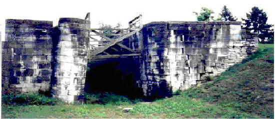
The Lockington Locks in 1998. Photo by Tom Homan.
'Canal' segment written in
December, 1998 by Rich Wallace
[ Back to Canal Index ]
|