|
Canal Index Page
The operation of the
canal spanned just 88 years, from the ceremonies to celebrate the beginning of
construction in 1825, to the abandonment of the canal after the disastrous flood of 1913. The canal was
built in three stages: the Miami Canal from Cincinnati to Dayton, the Miami Extension
Canal which extended from Dayton to the Wabash & Erie Canal at Junction, Ohio
(including the portion in Shelby County, Ohio), and the Wabash & Erie Canal, which was
built by the state of Indiana and connected Lake Erie to Terre Haute, Indiana. An act of
the Ohio legislature in 1849 named the entire system the Miami & Erie Canal.
The canal entered the county southwest of Lockington, following Loramie
 Creek for much of the way, with an aqueduct carrying the waters of the canal across the
creek south of Lockington. Three miles to the north, the
canal entered the small community of New Bern, turned west for a short distance, and then
headed northward again. The canal passed through Newport,
Fort Loramie, Minster, and then New Bremen. Creek for much of the way, with an aqueduct carrying the waters of the canal across the
creek south of Lockington. Three miles to the north, the
canal entered the small community of New Bern, turned west for a short distance, and then
headed northward again. The canal passed through Newport,
Fort Loramie, Minster, and then New Bremen.
The highest point along the route between Cincinnati and Toledo was a plateau called
the 'Loramie Summit,' beginning at Lockington and ending at New Bremen. The water flowed
south to the Queen City from Lockington, and from New Bremen north to Lake Erie. Port
Jefferson and Sidney were connected to the canal by the Sidney Feeder, an extension of the
canal designed to bring water from the Great Miami River at Port Jefferson to Lockington.
The entire Miami & Erie canal took 45 years to build.
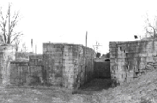
Over the 224 mile route, 103 locks, 19 aqueducts, and 3 reservoirs were constructed. With
the addition of feeder canals, such as the Sidney Feeder, over 300 miles of canals were
built. The total cost of the project was over 8 million dollars. Construction and
operation of the Sidney Feeder had a tremendous economic impact on Sidney and Port
Jefferson. When north-south and east-west railroads were built through Sidney by 1856,
however, the importance of the canal to the county began to decline. The great flood of
1913 washed out major sections of the canal, effectively ending this important era of
Shelby County, Ohio’s history.
[ Return to Archives Home Page ]
|