| The first ‘roads’ were actually
trails made by the Indians which they used to move from one village to another. According
to Mr. Leonard Hill, two primary trails crossed Shelby County, Ohio. One known as the
"Miami Trail" came up from the south through Miami County on the east side of
the Great Miami River as far as Piqua. From that point, it followed the west side until it
reached the well-known Indian village site near the mouth of Loramie’s Creek where it
turned northwest in a direct line to the site of Loramie’s
Trading Post and Fort Loramie built by General Wayne in 1795. After going north for a few more miles it divided; the western division going to
the Indian village where Ft. Wayne is now located, the eastern portion crossing over to
and following the Auglaize River to the Maumee River and on north to Detroit. General
Harmar followed that trail all the way across Shelby County. A portion of Harmar’s
Route through Miami County is marked above on Mr. Hill’s hand-drawn map which he
produced in 1948.
In 1949,
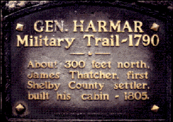
the Shelby County Historical Society erected a marker commemorating both the location of
the county’s first settler and General Harmar’s Military Trail of 1790. Everyone
is encouraged to pay a visit to the spot. The best time to go is in the fall after the
crops have been harvested, it is easy to imagine what life must have been like in the
early days. The marker is located eight miles west of Sidney, on Hardin-Houston Road,
along Loramie Creek, just west of the Bunker Hill Church. To reach, take State Route 47
west out of Sidney to Hardin. At Hardin-Wapak Road, take a left. Follow this to
Hardin-Houston Road and take a right. The Wilson Home (first brick home in Shelby County)
is the first monument on the left, (approximately one mile west); the Harmar/Thatcher
marker is nearly two miles further, on the right (north-side), of Hardin Rd, surrounded by
a black fence.

'Indian' segment written in December, 1997 by David Lodge
[ Back to Indians Index ]
|

